COASTAL AREAS/MANGROVE FORESTS
The Sindh coastal region is located in the southeastern part of the country between the Indus border along the Sir Creek on the east, and the Hub River along the Balochistan coast on the west. This coastal region is about 350 km long and can be divided into the Indus Delta/Creek and Karachi coast.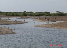
The main vegetation found around the coastal areas are mangrove forests. Mangroves provide breeding ground for variety of fish, shrimps, crabs and other invertebrates and also are of great significance as a source of nutrients for fisheries. Since majority of the people residing near or around the coastal areas are engaged in fishing and related activities, mangroves make an important contribution to the local and national economy.
The most commonly distributed specie is Avicennia marina (Grey mangrove or Timar) that comprises 99% of the total vegetation.
The coastal wetlands attract a number of migratory birds, particularly waterfowl. Two species of turtles are also found in the shores of the Karachi coastline. These are the Green Turtle (Cheldnoia mydas) ad Olive Ridley Turtles (Lapidochely).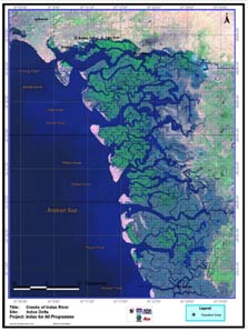
A major threat to the coastal biodiversity of Sindh is pollution. Untreated industrial effluents and agricultural run-off are the major sources of coastal and marine pollution. Effluents containing led, mercury and other heavy metals mainly from tanneries are most harmful to marine life, It is estimated that annually about 37,000 tonns of industrial waste is being dumped in the coastal environment of Karachi, whereas 20,000 tons of oil finds its way to beaches and harbours and the fishing grounds of Karachi annually.
RIVERINE FORESTS
The riverine forests in the province of Sindh occur along both banks of the Indus River. They rely on inundation by the River for irrigation and therefore their existence is heavily dependent on the intensity, duration and frequency of river water flow .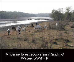
The newly deposited soils support the growth of species like Saccharum bengalense, Saccharum spontaneum, Tamarix dioica, Tamarix indica and Populus euphratica. As the land becomes stable vegetation comprises of species like Acacia nilotica, Prosopis cineraria and Cynodon dactylon. Under arid conditions vegetation is comprised of species like Prosopis cineraria,Salvadora persica, S. oleoides, Capparis decidua, Acacia senegal, A. jacquemontii,
Rivereine forests are the mainstay of forestry in Sindh. Besides providing a source of livelihood for thousands of people, these forests provide fuel wood, timber, fodder, honey and tannin. Moreover, they serve as carbon sinks and also protect the surrounding areas from the severity of floods .
 In recent times, only 50 percent of the gross area of riverine forests is inundated even in high floods. As a result, the riverine forest area is shrinking alarmingly while less salt tolerant species have almost disappeared. The existing condition is likely to further deteriorate with the construction of new dams and barrages, enabling only 20 percent of the original forest area to get inundated. In recent times, only 50 percent of the gross area of riverine forests is inundated even in high floods. As a result, the riverine forest area is shrinking alarmingly while less salt tolerant species have almost disappeared. The existing condition is likely to further deteriorate with the construction of new dams and barrages, enabling only 20 percent of the original forest area to get inundated.
FRESHWATER LAKES
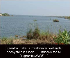 Sindh is home to two of the largest freshwater lakes in Pakistan, Keenjhar and Haleji, which are also internationally recognized as important for a wide variety of breeding, staging, passage and wintering waterbirds. Some of the wintering birds that have been seen around these lakes include ducks and geese, shorebirds, flamingos, cormorants, herons and egrets, ibises, coots, gulls, terns etc. Sindh is home to two of the largest freshwater lakes in Pakistan, Keenjhar and Haleji, which are also internationally recognized as important for a wide variety of breeding, staging, passage and wintering waterbirds. Some of the wintering birds that have been seen around these lakes include ducks and geese, shorebirds, flamingos, cormorants, herons and egrets, ibises, coots, gulls, terns etc.
Freshwater lakes are an important source for drinking water and fisheries It is estimated that Sindh freshwater lakes account for 65 percent of total freshwater fisheries in Pakistan and over 120 species of freshwater fish found are found in Sindh.
However, decrease inflow of water from River Indus is causing significant damage to these wetlands. With dropping water levels, inflow of industrial wastewater from the Kotri industrial area, and sewage and garbage from the communities in the vicinity many fish and vegetation species are dwindling in number and diversity in the Keenjhar lake is on the decline. Similarly, Haleji Lake is also in danger as it is faced with the problem of eutrophication. Although the lake is rich in nutrients and supports a dense plant population, animal life is threatened by a lack of oxygen .
DESERT
The desert region in Sindh covers an area of approximately 68,000 km and comprises of Thar, Nara and Kohistan.
The Thar region is mainly in the Tharparkar district and extends southwards along the Runn of Kutch. It extends over an area of 23,000 km and has a population of one million people. The Nara region spans 22,000 km and its upper portion lies in four districts: Sukkar, Nawabshah, Khairpur and Sanghar. Finally, Kohistan, with a coverage of 23,000 km comprises of parts of Dadu, Larkana and Thatta. 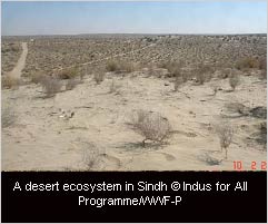
These areas are characterized by large tracts of barren land that receive very little rainfall leading to frequent drought-like conditions. The vegetation primarily comprises of stunted scrubs.
The desert areas are among the poorest in Pakistan, with lack of infrastructure facilities health, education etc. Majority of the people are involved in livestock production and cattle raising. However, due to limited or no access to resources, and lack of education and training, the locals are not able to maximize their economic potential. Traditional methods of livestock breeding are still being practiced and animal mortality rate remains quite high due to malnourishment during drought periods. Since rain is the main source of water and therefore agriculture and livestock activities are dependent on rainfall, the failure of monsoon means no fodder for the cattle and livestock. Further, to compound the problem poor transportation links make import of fodder from other areas quite expensive and therefore unaffordable for the locals.
Sources: IUCN (2004), Sindh State of Environment and Development, Sindh Programme Office
http://www.tharparkar.sdnpk.org/prothar.htm
(Source: The New Oxford Atlas for Pakistan) Map of Desert Region of Sindh
IRRIGATED LANDSCAPES
Irrigation is a major source of water for Sindh’s agricultural resources. While the actual irrigated area varies annually, subject to the availability of water, the total cultivated command area (CCA) in Sindh is equivalent to 5.1 million hectares and around 1.3 million hectares is classified as cultivable waste i.e. land which could be brought under cultivation if irrigation water were available. 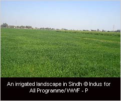
Irrigation water that is received from River Indus is channelized through the Sukkar, Kotri and Guddu Barrages irrigation systems. The irrigated areas of the province have been divided into five zones out of which three are major agro-ecological zones. These are as follows:
Zone-A: Rice/Wheat zone of the Right Bank of river Indus (upper Sindh).
- Sub-Zone A1 Main area
- Sub-Zone A2 Piedmont soil region
Zone-B: Cotton/Wheat zone of the left bank of River Indus.
- Sub-Zone B1 Guddu Barrage command area
- Sub-Zone B2 Sukkur Barrage command area
Zone-C: Rice/Wheat/Sugarcane zone of lower Sindh.
Besides the three agricultural zones, Zone D, comprises of deserts in the east of Sindh, and Zone E is the western hilly zone.
A major challenge faced by the irrigated areas is decreased flow of water from River Indus. Lack of irrigation water, forces people to extract groundwater where feasible to cultivate their lands exacerbating the problem of water logging and salinity. It has been estimated that due to flawed irrigation practices and lack of drainage facilities half of the cultivated area in Sindh has been affected by the menace of water logging and salinity, significantly reducing the crop yield and thereby negatively impacting the livelihood of people.
Source: Azad, A (2003) Sindh Water Resources Management: Issues and Options, FAO Investment Centre, Occasional Paper Series No.15.
BRACKISH AND SALT LAKES
The Indus ecoregion is home to a number of brackish and salt lakes such as Drigh Lake, Jhubo and Nurri lagoons and a large number of seasonal or permanent lakes in Deh Akro-II wetlands complex..
Drigh is a small, slightly brackish lake, with extensive marshes, situated in the Indus floodplain. It lies 18 km west of Larkana and hosts over 20,000 waterbirds, mostly ducks, geese and coot. It is also a breeding and wintering area for a wide variety of waterbirds and an important roosting site for night-heron. The Lake was declared a wildlife sanctuary in 1972, and in 1976 it was also designated a Ramsar site.
Jubho Lagoon is a good example of a natural wetland, featuring a combination of brackish, coastal and inland lagoons and mudflats. It is a large shallow brackish lagoon with associated mudflats and marshes. The site is inter-connected with Pateji, Cholri and Nurri wetlands. Some salt-tolerant bushes can be found in the high lying areas of the wetland. The locals used this site for fishing and livestock grazing. The wetland is important for wintering waterbirds, particularly Greater and Lesser Flamingo and Dalamatian Pelican. Lesser Flamingo and Dalmatian Pelican are endangered species. Large scale hunting has reduced the number and diversity of migratory birds. As a result of the construction of the tidal link canal, salt water intrusion has taken place that has reduced the growth of freshwater vegetation. Also the agricultural run off has damaged the biodiversity of the area.
Nurri Lagoon is situated in the Golarchi subdivision of Badin District, 190 km southeast of Karachi. This is a natural wetland, featuring a combination of brackish coastal and inland lagoons and barren mudflats on the northern side. The site has consistently recorded a very large concentrations of migratory birds in winter. The different bird species found in the area include storks, snipes, crested terns, ducks and gulls. Nurri Lagoon comprises four inter-connected shallow wetlands with very sparse vegetation. This lagoon is connected with Jubho, Pateji and Cholri wetlands. All these wetlands are inter-connected and ultimately drain into a tidal link. The water is brackish. Salinity and sedimentation are increasing due to the intrusion of the sea in this area and water level is increasing due to the tidal effect. The site is not protected. The wetland is under threat by over population on the dwindling natural resource base. There has been a dramatic increase in fishing and illegal hunting activities over the past two decades. Also, agricultural and industrial pollution have aggravated the situation.
Deh Akro-II wetlands complex is located 330 km northeast of Karachi, in Nawabshah district. It is a natural wetland comprising 36 lakes, mostly brackish. The complex is a blend of f four major habitats types: desert, wetland, marsh and agricultural lands. The complex presents a unique example of desert wetland ecosystem that supports a variety of rare and endangered wildlife species. In total, the wetland supports more than 18 species of mammals, 16 species of reptiles, 14 species of fish, and 101 species of birds. The site regularly supports over 20,000 waterbirds. The wetland supports a small population of marsh crocodiles. The wetland is an important feeding and spawning ground for several indigenous fish species. The desert is characterised by sand dunes with well developed herbs/shrubs and trees. The agricultural land comprises patches of irrigated agricultural fields lying adjacent to the desert. The wetland fauna includes waterbirds, crocodiles, otters and fish. Land uses in the wetland include small-scale irrigated agriculture, subsistence fishing, conservation education and scientific research. In 1998, the wetland was declared a Wildlife Sanctuary.
|